
THE APENINES
From the lower hills which start from the south of the Via Emilia you can reach as far as the the highland ridges, which border Liguria and Toscana as they did in the Ducale era; in fact you can still see the boundary stones of the Ducato of Parma, Piacenza, and Guastalla. Here rise the highest peaks: Mount Maggiorasca (1799 m.); Mount Penna (1735 m.); Mount Orsaro (1831 m.).In this vast space the three principal valleys of the Ceno, the Taro, the Parma, carve the shape of the land, rivers which originate from a high altitude, open their way with an action of erosion which has given origin to the valleys - north and south. Seeing as it is impossible to indicate a single way, we suggest that you use two points of reference as instruments to use in travelling the roads, all perfectly roadworthy which lead to the ridges which in turn lead into the valleys or twist into the first hills. From many points the tourist can find marked passageways, walks or excursions like the passage which joins Lake Santo with the Cisa pass.
In the form of the towns, the castles, and parish churches, in the topology of the rural constructions, is shown the history and culture of all the valleys. As we know, man has lived in the mountains, sheltering villages and centres at the borders of old woods which are even today a living testimony. A lot of these are encounterd on the Parmense Apenines due to the importance of the roads which cross it.
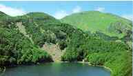
The first Regional National Park (Boschi di Carrega) was created on the Apenines and the Fluvial Parks of the Taro and Stirone have been recently established but even more numerous are the places and important natural monuments. The most important of all, are the group of galcial lakes which fill the small hollows along the high ridge in the boroughs of Corniglio and Monchio delle Corti.